Civic Tech Field Guide
Sharing knowledge and productively growing the fieldThe Tech > Civic data - (750)
This page curates everything from open government data to visualization tools to data standards to algorithmic implementation. The only common thread is that all these data and data products share a commitment to civic interests.
- Paris Tech Review: A brief history of Open Data
Showing 750 Results

gvSIG Desktop
Valencia (Spain)A powerful, user-friendly, interoperable GIS used by thousands of users worldwide.

Global Youth Participation Index
BrusselsThe GYPI is the first global tool that tracks and compares youth political participation in over 130 countries, measuring indicators like electoral inclusion, civic engagement, youth representation in parliaments, and more.

congressMCP
Austin, TXAn MCP server allowing AI agents and MCP clients to interface with the Congress.gov API

Voices of Venezuela
Latin AmericaVoices of Venezuela (VOV) is committed to empowering Venezuelan migrants through innovative, AI-powered solutions and community-driven initiatives.

BKK Follow Up
Bangkok, ThailandA 12-year retrospective of problems that have bothered Bangkok residents | สำรวจปัญหากวนใจชาว กทม.

Big Tech M&A Database
AmsterdamThe Big Tech tracker for mergers and acquisitions provides an overview of companies that have been acquired by Big Tech (2019-2025). Search for a merger!

Coefficient
LondonCoefficient is a data consultancy offering end-to-end services in data science, engineering, infrastructure, machine learning implementation and other AI-related services, as well as bespoke training courses.

Planning and housing data in England
United Kingdom of Great Britain and Northern Ireland (the)Official government portal for open planning and housing data

Humanitarian Action provides a comprehensive overview of the humanitarian landscape by providing both an annual snapshot complemented by analysis, and live data on on humanitarian crises and response.

OCHA carried out two global survey to assess the consequences of the US funding freeze on humanitarian action globally. The first round, in February, looked at the impact of the suspension orders and waivers. The second was launched in March following the announcement of the US grants’ termination, in collaboration with IOM, UNHCR and ICVA.

Data Governance Wegweiser
Humboldt-Institut Berlin, Invalidenstraße, Berlin, GermanyDu willst wissen, wie du Daten sinnvoll und rechtssicher in deinem Vorhaben einsetzen kannst?

政治獻金數位化 (g0v Campaign Finance)
Taiwan (T'ai-wan)Crowdsourced project to digitize campaign finance records and detect corruption

TheyWorkForYou Votes
United Kingdom of Great Britain and Northern Ireland (the)Votes in the UK’s Parliaments determine the laws that we all live by, and we want the information about who voted for what to be as accurate, easy to use and easy to understand as possible.

Lex-graph
United Kingdom of Great Britain and Northern Ireland (the)Building a knowledge graph of UK legislation

Verkehrszeichen in OpenStreetMap
Germany (Deutschland)Verkehrszeichen sind wertvolle Daten in OpenStreetMap.

Data Protection Commission of Ireland
Ireland (Éire)The Data Protection Commission (DPC) is the national independent authority responsible for upholding the fundamental right of individuals in the EU to have their personal data protected.

Citizens Data Agency
The University of EdinburghWe are a fictional service provider proposing five speculative data support services.

The Life and Times of Citibike #32606
New York City806 days, 8,624 trips, 7,060 miles. Thank you for your service.

Miami Affordability Project (MAP)
Miami, FLThe Miami Affordability Project (MAP) is an interactive online map providing data on the distribution of affordable housing, housing needs, demographic profiles, and environmental resiliency in greater Miami.

Open Infrastructure Map is an open-source map of the world's infrastructure using data from OpenStreetMap.

Violation Tracker UK
Washington, DCA Tool for Researching Corporate Regulatory Infringements in the United Kingdom

Good Jobs First
Washington, DCGood Jobs First is a national policy resource center that promotes corporate and government accountability in economic development.

Amazon Tracker
Washington, DCDiscover How Much the Public is Subsidizing One of the Largest Retailers

Subsidy Tracker
Washington, DCDiscover Where Corporations are Getting Taxpayer Assistance Across the United States

Violation Tracker Global
Washington, DCViolation Tracker Global is the first wide-ranging database on corporate misconduct around the world.

Civic Information Index
Internews Network, 15th Street Northwest, Washington, DC, USAThe Civic Information Index uses data to map drivers of engaged, informed, equitable, and healthy communities nationwide.

The uneven reach of the state: A novel approach to mapping local state presence
Norway (Norge, Noreg)A machine learning model trains on geo-located survey data to predict state presence.

Register of Charities
United Kingdom of Great Britain and Northern Ireland (the)Find information about registered charities in England and Wales

The Impact Project
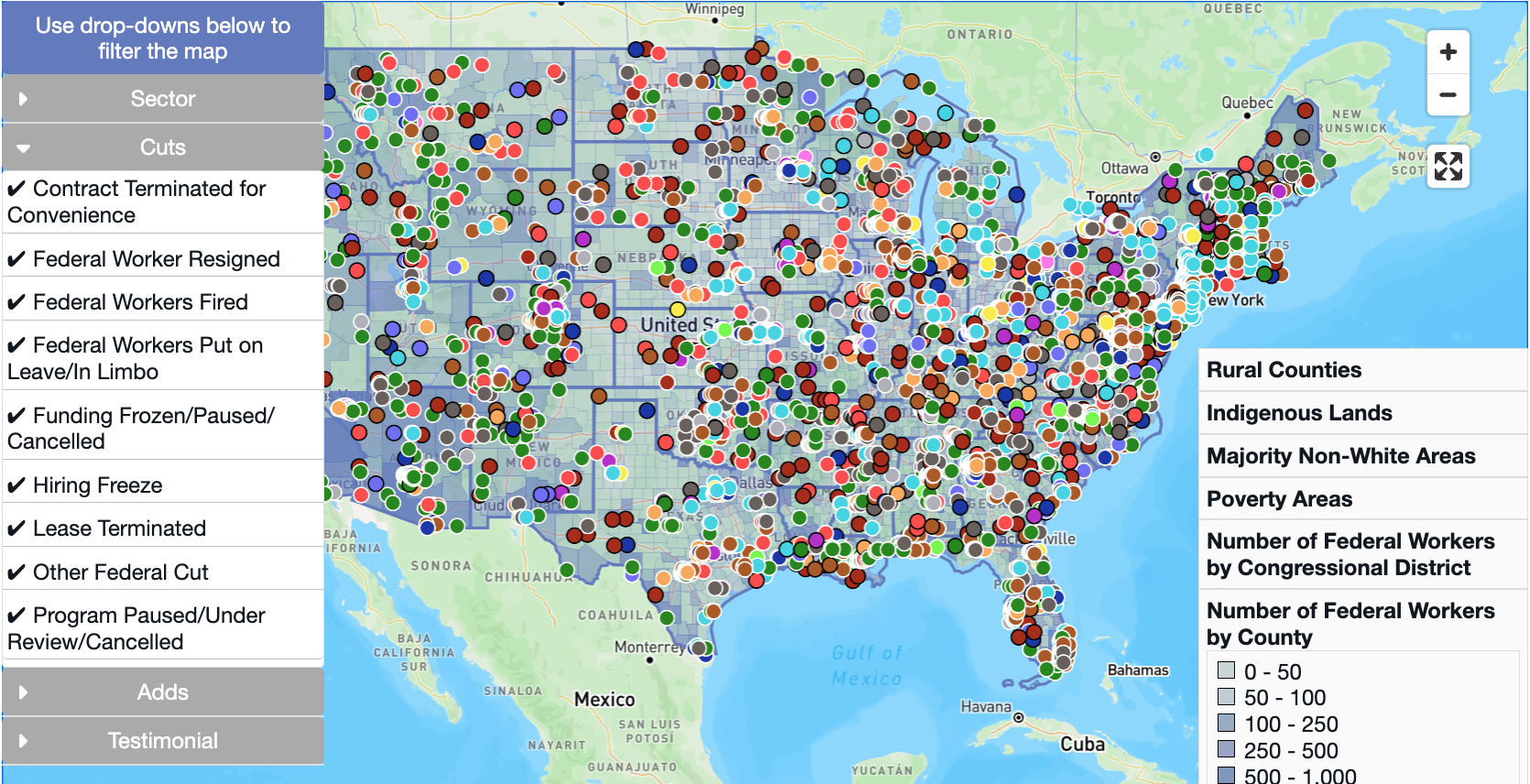
United States of America (the)The Impact Project provides objective, transparent, and open-source data to help explain how federal policies, funding, and workforce changes affect our communities.

The Impact Map
United States of America (the)The Impact Map provides timely data—as it becomes available—on policy, funding, and workforce changes and their localized effect. This tool is currently in beta and will continue evolving, so you may find areas that need updating.

360Giving Data Standard
LondonThe 360Giving Data Standard is a uniform and consistent way to describe grantmaking data.

We are a charity that helps organisations publish and use open grants data so that people can understand the funding context, make informed decisions, and work together to support communities and good causes as effectively as possible.

Data Entry and Exploration Platform (DEEP)
Williamsburg, VAA collaborative analysis platform for effective aid response

IFRC GO
Williamsburg, VAIFRC GO aims to make all disaster information universally accessible and useful to IFRC responders for better decision making.

Data Friendly Space (DFS)
Williamsburg, VAWe envision a future where technology and data power positive social change

Data Management and Compliance, Inc.
Lexington, MAWe build software solutions for Democratic campaigns and organizations, focused on compliance and data management.

The Political Party Database Project is a cross-national initiative to establish and update an online public database as a source for key information about political party organizations. Last updated 2022.

FCC National Broadband Map
Washington, DCThis map displays where Internet services are available across the United States, as reported by Internet Service Providers (ISPs) to the FCC. The map will be updated continuously to improve its accuracy through a combination of FCC verification efforts, new data from Internet providers, updates to the location data, and—importantly—information from the public.

Data Cameroon
Cameroon (Cameroon, Cameroun)DataCameroon est un site d’information généraliste, spécialisé dans le Data journalisme et le journalisme d’investigation.


Storytelling with Data Course
The New School, East 13th Street, New York, NY, USATaught by Maria Massei-Rosato

These are the results of a survey measuring the impact on organizations across the world affected by the US Government aid freeze.

Judge Profiles
Berkeley, CA, USAAccess data on immigration judges, including cases, backlogs, grant rates, and removal statistics

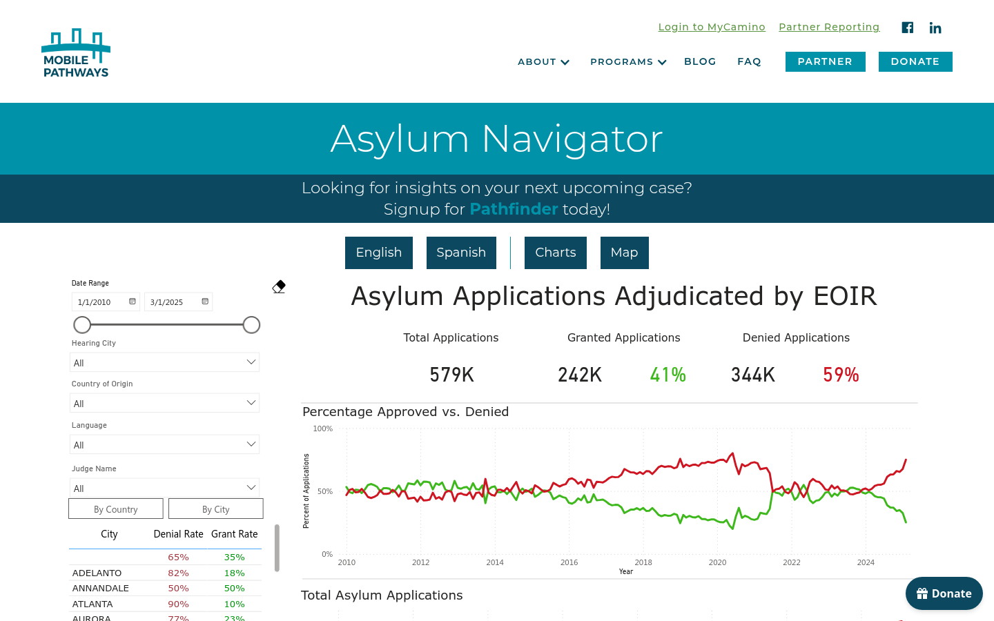
Asylum Navigator
Berkeley, CA, USAAsylum Navigator is a groundbreaking data insights platform designed to empower immigration attorneys and human rights defenders.

The Institutional Data Initiative at Harvard Law School Library
Harvard University, Cambridge, MA, USAStrengthening society’s connection to knowledge by advancing our access to and understanding of the data that shapes AI.


