Civic Tech Field Guide
Sharing knowledge and productively growing the fieldThe Tech > Emerging tech > Smart Cities and sensors - (112)
Technology that quantifies the physical environment, such as traffic or environmental factors
Recommend resources:
- CivicSpace.tech guide to IoT & Sensors, including its relevance to civic space, opportunities, risks, and case studies
Showing 112 Results

HalexDream!
Saitama, JapanProviding weather, earthquake, disaster prevention and lifestyle-related information as well as consultation on its usage.
Smart Cities Council
Washington, DCWelcome to the world's leading organization for Smart Cities, Smart Buildings, Strategies, Policy, Research and Technologies.
Smart Cities Council Podcast
Washington, DCJoin us as the Smart Cities Council team and members from around the world talk to the people and places advancing the application of science, data, technology, and engineering aiming to create a safer, more beautiful, enabled, and resilient future for everyone.

WTF Podcast - What is the Future for Cities?
Washington, DCWhat is The Future for Cities? podcast is a platform to introduce and connect people who are actively and consciously working on the future of cities and to introduce research about the future of cities.
Innovations for the mobility transition
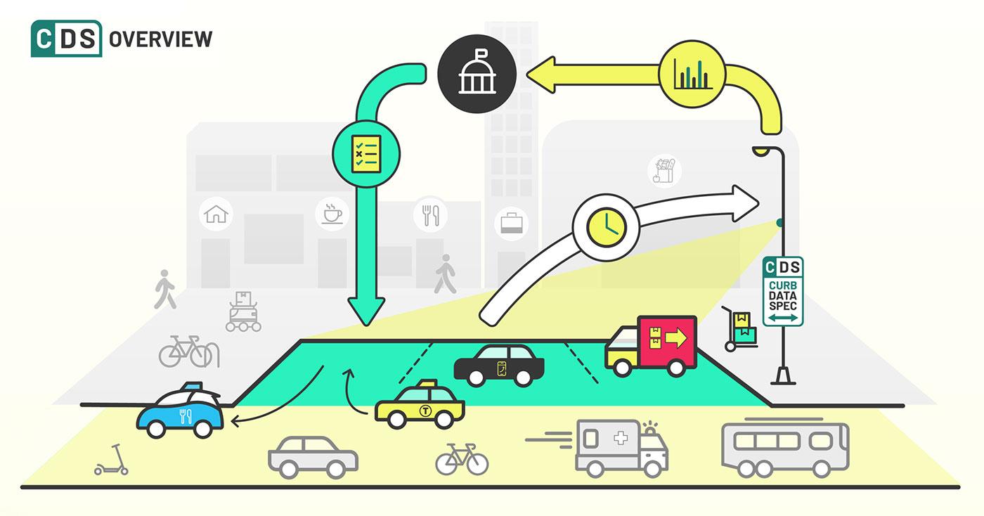
Curb Data Specification (CDS)
CaliforniaA digital tool that helps cities and companies pilot and scale dynamic curb zones. CDS provides a mechanism for expressing static and dynamic regulations, measuring activity at the curb, and developing policies that create more accessible, useful curbs.

Air Quality Time Series Forecasting Using Machine Learning Algorithms
Asunción, ParaguayThis study aimed to develop accurate short-term air quality forecasting models for Asunción, Paraguay using machine learning algorithms.
Automotus
Los Angelestackling safety hazards, congestion, compliance and emissions. automated curb management for cities + airports
Urban Tech Summit
Roosevelt Island NYCThe Summit will offer practical insights and examples of how researchers, companies, governments, and communities can continue to drive innovation amid these headwinds—and how urban tech can help cities do more with less as they prepare for the future.
Smart City Data Governance
OECD, Rue André Pascal, Paris, FranceKey trends in smart city data governance
STRONG Manoomin Collective
United States of America 🇺🇸The STRONG Manoomin Collective is a tribally-driven research effort that aims to strengthen Ojibwe resilience by supporting development of scientific and environmental governance capacity.

+(1).png)
Boston Curb Usage Map
BostonTo solve these challenges, the Streets Cabinet and Innovation and Technology Cabinet are building a digital map of Boston’s complex curb network and regulations.


MeshPoint One
European Union (EU)MeshPoint One believes that access to Internet is one of basic human rights. Their mission is to enable Internet access and improve the quality of life for people in disaster struck areas. Also by empowering people in rural communities to take action to build their own village telecoms to address disadvantage, become more sustainable and increase local control. Currently, they are focused on Syrian refugees in Croatia.

End Police Surveillance
ChicagoShotSpotter creates thousands of unfounded police deployments, fuels unconstitutional stop-and-frisk, and can lead to false arrests.


Report by Ending Youth Surveillance and NOTICE Coalition published November 2024

SAGA Smart Machinaka Project
Saga, JapanThe SAGA Smart Machinaka Project is a demonstration project that aims to improve the convenience of the city center of Saga City through the use of technologies such as AI and IoT, and to create a city that is easy to live in.

Counting trucks for environmental justice

Using numerous cities from different regions around the globe, the book compares how smart cities of different sizes are evolving in different countries and continents.

Highlighting a wide range of topics including community inclusion, cultural innovation, and public safety, this book is ideally designed for urban planners, entrepreneurs, engineers, government officials, policymakers, academicians, ...

Using Technology to Empower Rural and urban last mile communities across Nigeria

When 'doing ethics' meets public procurement of smart city technology – an Amsterdam case study
Amsterdam[A] multi-stakeholder co-design project – including a citizen panel – is an integral part of the process in which the service is designed and realized

The Atlas of Urban Tech
Cornell TechA global atlas of case studies of tech-enabled urban districts and municipal digital masterplans.

Air Quality Improvement and Monitoring
New York City (NYC / New York, NY)6-month pilot of three pole-mounted static air quality machines

Let's build an open, free and community-owned IoT data network for New York!

The Things Network
AmsterdamWe are a global collaborative Internet of Things ecosystem that creates networks, devices and solutions using LoRaWAN®.

Internet of Things pilots to improve quality of life in London neighborhoods

Academy of the Near Future
Dublin, IrelandIreland's Smart Cities Education Programme designed for young people and local authority staff.

Atlas of Urban AI
BarcelonaATLAS is a crowdsourced (map) repository of projects happening in cities involving the use of artificial intelligence systems.
Smart Districts
Dublin, IrelandSmart Districts (Dublin) are strategically selected locations where innovation projects are fast-tracked.

Nordic Smart City Network
EuropeThe Nordic Smart City Network is a collaboration initiative joining five Nordic countries, and currently 20 Nordic cities with a common goal: to explore the Nordic way to create livable and sustainable cities.

Copenhagen Solutions Lab
CopenhagenAt Copenhagen Solutions Lab, we support the development of the city through testing and implementation of intelligent and data-driven solutions, that support the needs of the city and its citizens.

BLOXHUB
CopenhagenBLOXHUB is the Nordic Hub for Sustainable Urbanization.

DOLL Living Lab
CopenhagenOur expansive 1.5 km2 industrial area, frequented by over 10,000 daily users, functions as a vibrant physical testing space of smart city environments – now also offering a real-world platform with a digital twin for urban innovation at a 1:1 scale.

Location Aware Sensing System (LASS) Environmental Sensor Network
Taiwan (T'ai-wan) 🇹🇼LASS (Location Aware Sensing System) is an open source and public welfare "environmental sensor network system". 是一套開源和公益的「環境感測器網路系統」

C² Challenge
Denver, COThe C² Challenge provides an open-ended innovation process for government procurement that removes the need to meet specific requirements and provides an open door to business and academic innovators to propose new ways of solving a problem.

Urban Platform
Portugal 🇵🇹A web solution designed for governments that provides the digital twin of the city, and delivers a real-time view of every street, plus insightful analytics to support decision-making and increase the efficiency of the city operations.

Living-in.EU
Estonia (Eesti Vabariik) 🇪🇪Join us in building the European way of Digital Transformation for 300 million Europeans

Jacobs Urban Tech Hub at Cornell Tech
Cornell TechMaking cities stronger, fairer, and more resilient through responsible technology.

Smart Cities Certificate
Denver, COThe certificate in Smart Cities is an interdisciplinary program designed for working or aspiring professionals and upper-level students interested in expanding their knowledge-base in the fields of emerging urban technologies, data science, sustainable design, and public-private partnerships.

Maai Makwa (My Water)
Kenya 🇰🇪Deploying Open Data to Enable Kenyan Households & Communities Conserve Fresh Water Resources, including civic literacy campaigns and IoT monitoring of water supply and quality

A Reuters special report investigating global supply chains and sustainability programs

#STOPSHOTSPOTTER
United States of America 🇺🇸A coalition working against ShotSpotter's "harmful impacts on the Black, brown, and poor people that the company surveils."

Low-Cost Sensors and Systems for Ocean Discovery
Rhode IslandWe are creating low-cost, easy-to-use deep-sea systems that gather the most critical data to inform environmental decision-making and deployment strategies.

An Earthquake Early Warning System for the West Coast of the United States

Accelerator for America
United States of America 🇺🇸Accelerator for America and Honeywell Collaborate to Promote Smart City Growth in Five U.S. Cities

The national voice of municipalities relating to information and communications technology.

The Sounds of CDMX
Mexico City, CDMX, MexicoThis is an audio/visual story exploring the sounds of Mexico City’s streets.
Get email updates
Helpful Links
Reach Out
A project of

With support from
National Endowment for Democracy
Founding Organization
Civic Hall
Technology partner

