Civic Tech Field Guide
Sharing knowledge and productively growing the fieldSearch Results - disaster (237)
Showing 237 Results

Nexus Environment Assessment Tool (NEAT+)
Williamsburg, VARapid and simple project-level environmental screening for humanitarian operations

IFRC GO
Williamsburg, VAIFRC GO aims to make all disaster information universally accessible and useful to IFRC responders for better decision making.

Internal Displacement Monitoring Centre (IDMC)
Williamsburg, VAThe world's leading source of data and analysis on internal displacement

Data Entry and Exploration Platform (DEEP)
Williamsburg, VAA collaborative analysis platform for effective aid response

Gender-Based Violence Area of Responsibility
Geneva, SwitzerlandThe GBV AoR brings together non-governmental organisations, UN agencies, academics and others under the shared objective of ensuring life-saving, predictable, accountable and effective GBV prevention, risk mitigation and response in emergencies, both natural disaster and conflict-related humanitarian contexts.


Sahana makes high quality information management systems for emergency preparedness, response, recovery and resilience-building accessible to all.

Data Friendly Space (DFS)
Williamsburg, VAWe envision a future where technology and data power positive social change

GANNET
Williamsburg, VAGANNET is a Generative AI Initiative, offering AI-powered tools built to make knowledge and real-time information accessible to our community in a resource-efficient and ethical way.

Using publicly available satellite imagery and deep learning to understand economic well-being in Africa
Stanford University, Serra Mall, Stanford, CA, USAArticle in Nature by Christopher Yeh, Anthony Perez, Anne Driscoll, George Azzari, Zhongyi Tang, David Lobell, Stefano Ermon & Marshall Burke

USAID Resource Hub
United States of America (the)A centralized resource hub/database designed to support nonprofit and development professionals, organizations, and advocates navigating the impacts of the USAID shutdown—and beyond.

These are the results of a survey measuring the impact on organizations across the world affected by the US Government aid freeze.
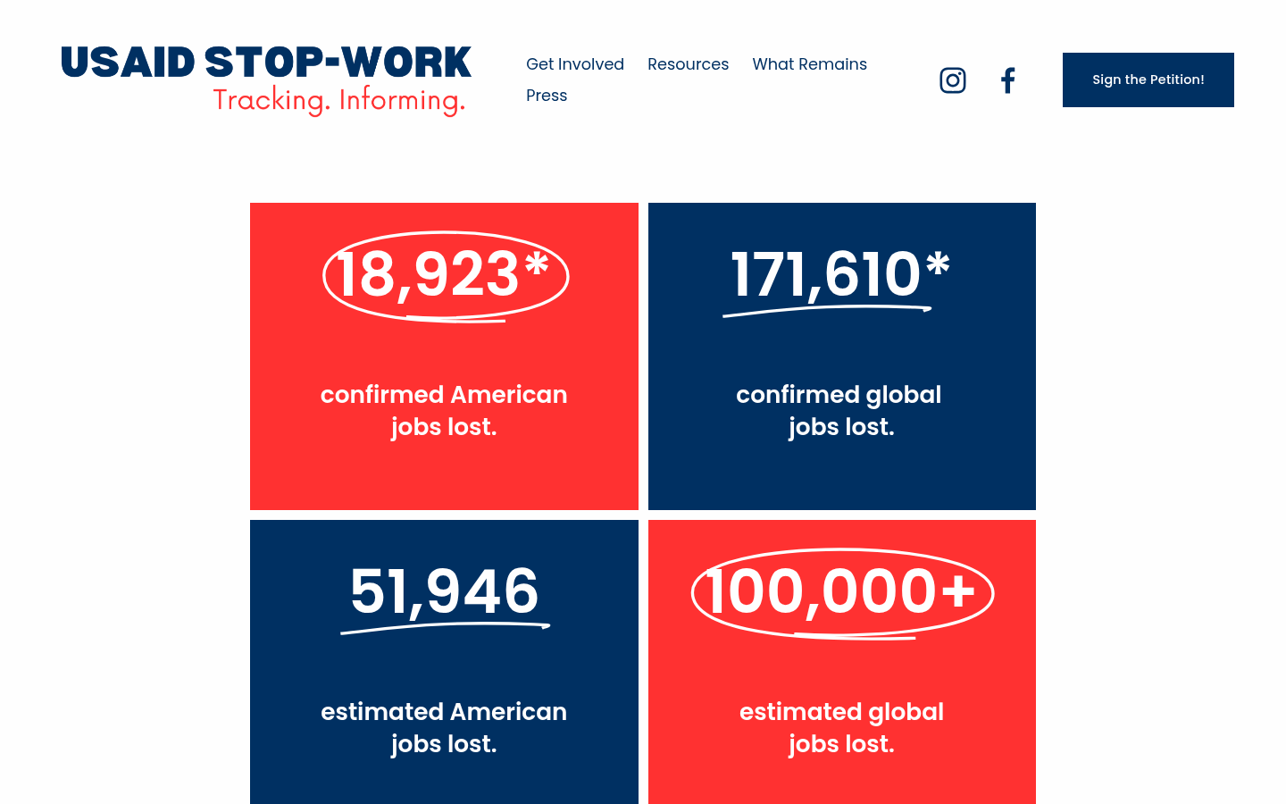
USAID Stop-Work
Cincinnati, OhioTracking. Informing.

Charities Affected by Freeze in Foreign Assistance Funding
United States of America (the)Charity Navigator's list of 3- and 4-star organizations whose programs may be affected by the Trump Administration's funding freeze.

Friends of USAID
United States of America (the)Organizing effort to fight for the life of USAID, including an instagram account with over 50,000 followers

CARE is a major international humanitarian agency delivering emergency relief and long-term international development projects. Founded in 1945, CARE is nonsectarian, impartial, and non-governmental. It is one of the largest and oldest humanitarian aid organizations focused on fighting global poverty.

Small donor campaign to help protect Kyiv from aerial bombing

Our vision is to build a world where AI technologies are secure, decentralized, and transparent, enabling users to harness the full potential of AI while maintaining complete control and privacy over their data.
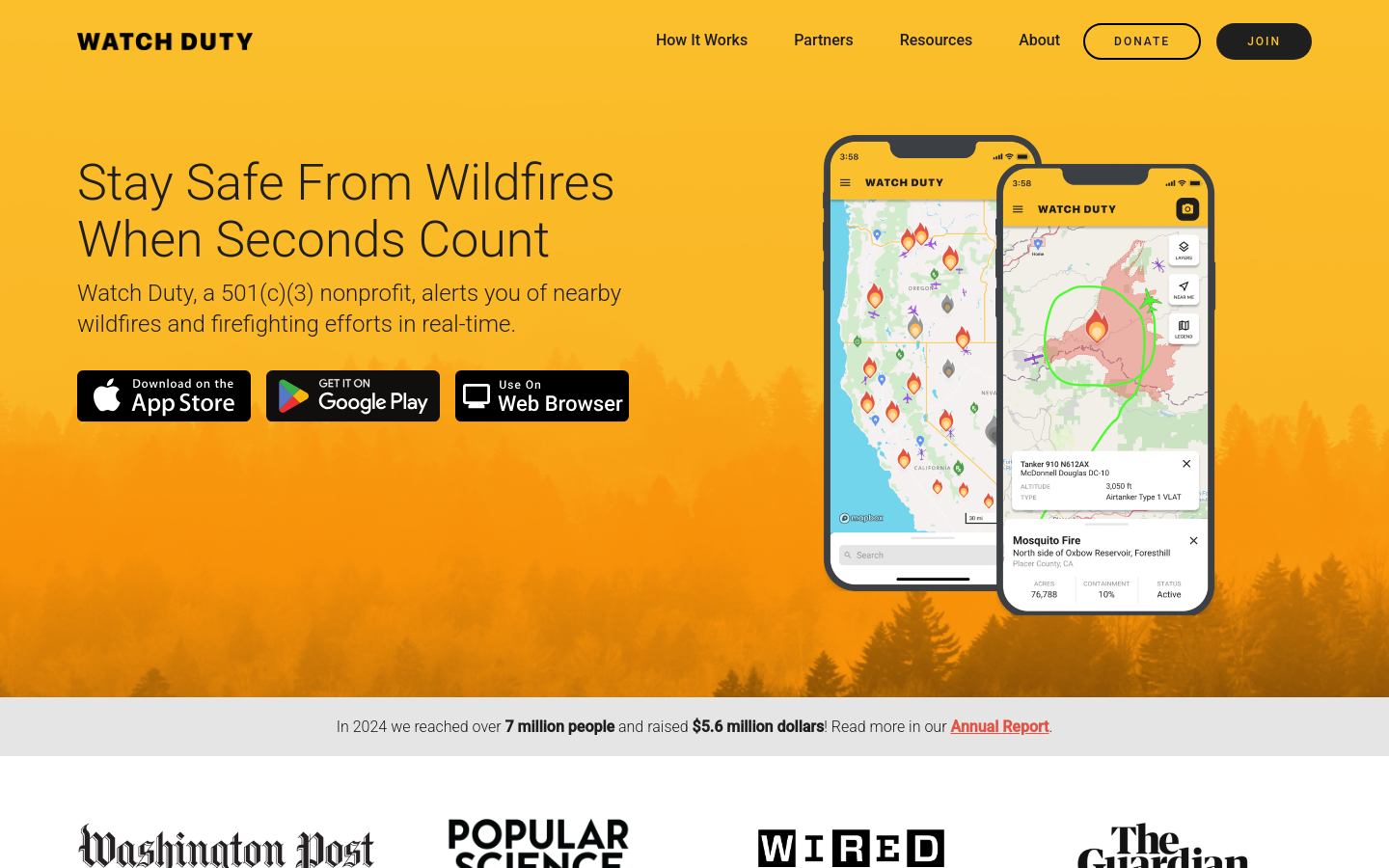
Watch Duty
Santa Rosa, California, USAWatch Duty, a 501(c)(3) nonprofit, alerts you of nearby wildfires and firefighting efforts in real-time.

EGOV Repositories
Guimarães, PortugalDiscover the United Nations University EGOV's repository platform, a centralized hub of specialized repositories tackling global challenges.

GAMA is an easy-to-use open source modeling and simulation environment for creating spatially explicit agent-based simulations.

GeoMSF Platform
Washington, DCA full suite of mapping and geodata tools developed by and for Medecins Sans Frontieres

AI for Changemakers
Poland (Polska)A global accelerator for AI innovators and nonprofits working to solve the world’s pressing challenges.
Evidence from Taliban-controlled Afghanistan shows that digital aid is a cost-effective, credible, and efficient way to reach vulnerable populations, in this case poor, tech-illiterate, female-headed households, in fragile states.

Swipe and tap. Put communities on the map. Help humanitarians find and help vulnerable people.

The Export Tool is an open service that creates customized extracts of up-to-date OSM data in various file formats.

MapRoulette has dozens of mapping Challenges that are created by experienced mappers. Each Challenge is about improving OSM in one very specific way
Rapid integrates advanced mapping tools, authoritative geospatial open data, and cutting-edge technology to empower OpenStreetMap mappers at all levels to get started quickly, making accurate and fresh edits to maps.

Mapeo is a free, easy-to-use, open source set of tools for collecting and mapping information. Mapeo was built by Digital Democracy with and for earth defenders to easily document environmental & human rights information and to collect data about their land. It was designed to work in entirely offline environments, is highly customizable, and built on a decentralized peer-to-peer database that allows communities to own their own data.

Launched by a collaborative effort between DataKind, Save the Children, and Microsoft, the Humanitarian Data Insights Project (HDIP) harnesses the power of generative AI to streamline data from multiple sources, making it accessible and interpretable for humanitarian workers at all levels of data maturity.

Using numerous cities from different regions around the globe, the book compares how smart cities of different sizes are evolving in different countries and continents.
This book provides the most current and comprehensive overview available today of the critical role of information systems in emergency response and preparedness

The book offers a valuable interdisciplinary dialogue on the challenges and opportunities of the increasingly influential space of civic media
Providing much needed insights for theory, policy, and praxis, this volume will be of interest to academics and students of public affairs, public management, governance, public health, public policy, and disaster and emergency management,
The first book devoted to a critically important aspect of disaster planning, management, and mitigation Technology and Emergency Management, Second Edition describes best practices for technology use in emergency planning, response,

Mapping debris cleanup following Hurricane Beryl 2024


Damage assessment software designed to rapidly and accurately collect damage assessments for FEMA’s disaster declaration process

Modernized Volunteer Management for Emergency Preparedness, Response, and Recovery
Data For Crisis
TallinnA collaborative work between DW Akademie and SocialLab to provide credible raw and aggregated data from Social Networks about crisis-related topics like COVID and Migration to support media practitioners and researchers with free access to public data

FloodLight
PakistanA Code for Pakistan initiative to Crowdsource the flood-related data from the 2022 Floods in Pakistan.

KIKI, Virtual Human Interpreter
Japan (Nihon or Nippon)The world's first text-to-sign interpreter for emergency alerts
SimpliCity
India (Bhārat)A comprehensive platform designed to enhance public safety and community engagement by revolutionizing civic communication and emergency notification systems, empowering individuals and government agencies to interact seamlessly and effectively.

Portable Network Kits
New York City, NY, USAThe Portable Network Kit (PNK) is a wireless network in a suitcase that helps people understand how to build their own mini-internet – and with it, how the internet works and might be owned and governed more equitably.

Bangladesh Open Innovation Lab (BOIL)
Dhaka, BangladeshOur aim is to build a community that supports the Open Data and uptake of the Living Lab paradigm.

Climate Intelligence (CLINT)
EuropeThe CLIMATE INTELLIGENCE – alias CLINT – project is a European-funded project whose main objective is to develop an Artificial Intelligence framework composed of Machine Learning techniques and algorithms to process big climate datasets for improving Climate Science...

HURREVAC
Richmond, VAHURREVAC is the decision support tool of the [US] National Hurricane Program, administered by FEMA, the USACE, and the NOAA National Hurricane Center.

Hurricane Mapping (Sea Island Software)
Richmond, VAWe are Sea Island Software, Inc., a company specializing in hurricane threat assessment. HurricaneMapping.com is our storm tracking service for Google Earth and ESRI's ArcGIS.

British Red Cross
United Kingdom of Great Britain and Northern Ireland (the)The British Red Cross helps people in crisis, whoever and wherever they are. We are part of a global voluntary network, responding to conflicts, natural disasters and individual emergencies.
Get email updates
Helpful Links
Reach Out
A project of

With support from
National Endowment for Democracy
Founding Organization
Civic Hall
Technology partner

 Civic Tech Field Guide