Civic Tech Field Guide
Sharing knowledge and productively growing the fieldSearch Results - mapping (234)
Showing 234 Results

Exposing protection gaps in digital transformation programmes


To highlight the global knowledge base of behavioural insights work in public policy, and bring the achievements of institutions to the fore, the OECD launched the Behavioural Insights Knowledge Hub and map in 2021.

We are identifying the organizations and leaders creating digital community-building platforms that strengthen our democracy.

Mapping NGOs Repairs
Raymond Ghosn Building, American University of Beirut, Maroun Semaan Faculty of Engineering and Architecture PO Box. 11-0236 Riad El Solh 1107 2020, Beirut LebanonBetween March and September 2021, BUL researchers identified around 80 NGOs that participated in shelter repair within the neighborhoods severely affected by the August 2020 port blast. The data and findings are presented through a recent mapping output on the Beirut Urban Observatory.

Mapping videos of the capitol seige
Capitol HillMapping the videos of the US Capitol building attack

Mapping Makoko
NigeriaA combined tech and journalistic effort to map the Makoko informal settlement

Mapping LA
Los Angeles, CAThis regional view is your portal to individual maps and statistics for 158 cities and unincorporated places and 114 neighborhoods within the city of Los Angeles.

A blog post covering ways to map the media ecosystem

Hurricane Mapping (Sea Island Software)
Richmond, VAWe are Sea Island Software, Inc., a company specializing in hurricane threat assessment. HurricaneMapping.com is our storm tracking service for Google Earth and ESRI's ArcGIS.

Data Mapping Cornwall
CornwallData Mapping Cornwall provides a summary of this spatial investigation of Cornwall, conducted by a large team of academics, experts and postgraduate students between September 2016 and March 2017.

Because OpenStreetMap is a crowd-sourcing project where everyone can freely contribute to the map, the Humanitarian OpenStreetMap Team has devised measures to support high-quality crowd-sourced OSM data.

Open Mapping Hub - Eastern and Southern Africa
Southern and East AfricaThe Open Mapping Hub - Eastern and Southern Africa exists to serve communities in the region by supporting the creation, maintenance, distribution, and use of high-quality open maps that are relevant for and contributed to by local communities.

Media Mapping
United States of America (the)Identifying audiences via TV, internet and news consumption patterns

In Close Up at a Distance, Laura Kurgan offers a theoretical account of these new digital technologies of location and a series of practical experiments in making maps and images with spatial data.

CUNY Mapping Service
New York CityThe CUNY Mapping Service at CUR engages with foundations, government agencies, businesses, nonprofits, and other CUNY researchers to use spatial information and analysis techniques to develop and execute applied research projects.

Stewardship Mapping and Assessment Project (STEW-MAP)
New York CityTo take part in STEW-MAP, a person or group collects data from stewards serving their community.

STEW-MAP: The Stewardship Mapping and Assessment Project
11 Campus Blvd, Newtown Square, PA 19073, USAData to understand who is working in a given region and what are their assets; this can improve outcomes for many applications, at multiple scales.

Opioid Mapping Initiative
United States of America (the)Local governments working together to address the epidemic with data and maps

A free, user-friendly, extendable application and API for drone image processing.

The Anti-Eviction Mapping Project is a data-visualization, data analysis, and storytelling collective documenting dispossession and resistance upon gentrifying landscapes.

Building on our previous publication of similar high-resolution population maps for 22 countries, we're now releasing new maps of the majority of the African continent, and the project will eventually map nearly the whole world’s population. Using weakly- and semi-supervised learning.

mxDistritos
Mexico City, CDMX, MexicoThe repository contains maps of Mexican districts used to elect representatives to various offices and code for data systematization and analysis. The primary source are shapefiles publicly distributed by INE (formerly IFE, Mexico's national election board, page here). Data in this repo is prepared for mapping and statistical analysis.

Bangladesh Open Innovation Lab (BOIL)
Dhaka, BangladeshOur aim is to build a community that supports the Open Data and uptake of the Living Lab paradigm.

CoreData.nyc is New York City’s housing and neighborhoods data hub, presented by the NYU Furman Center.
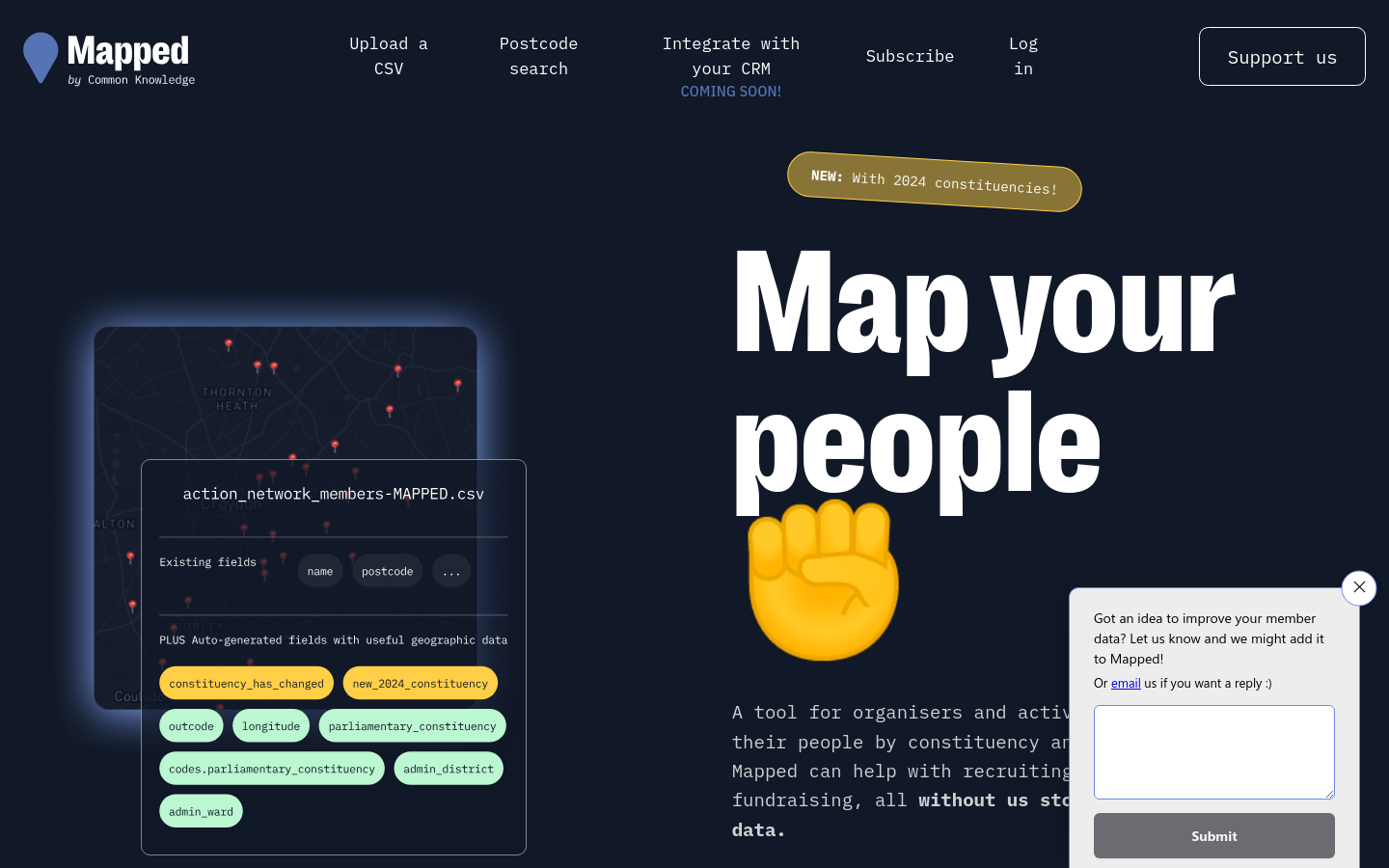
Mapped
The United Kingdom of Great Britain and Northern IrelandMapped integrates with common organising platforms like Airtable, Mailchimp and Action Network to augment membership lists with other useful data sources.

OpenPV
Germany (Deutschland)Currently a solar potential look-up tool for the German state of Bavaria. "We support the roll-out of more photovoltaic roof systems."

FedGeoDay
Washington, DCFedGeoDay is THE event devoted to "open geospatial ecosystems" (open source software, open/collaborative mapping, open science challenges, and open engagements) that are used to initiate and grow capabilities across the U.S. federal government.

Mapatón Ciudadano
XalapaMapeo de rutas para futuras ciudades sostenibles

Cycling updates to Google Maps now take account of traffic conditions and the availability of high-quality cycling infrastructure

Postcode => Westminster constituency converter
The United Kingdom of Great Britain and Northern IrelandEnter a UK postcode and this tool returns the constituency it belongs to


digitize your city
Valencia, Carabobo, VenezuelaDigitize your city is a series of actions that seek to create a friendlier environment through the use of technology previously influenced by us and the data we consciously create and deliver.

Urban Analyst provides interactive maps of the properties of cities including of their transport systems and socio-demographic conditions, as well as statistical summaries of all cities.

We provide research and development to support decision making in the field of sustainable mobility and humanitarian aid. We accomplish this through open geoinformation, open methods, open software and close collaboration with our partners.


Safecity
United States of America (the)Safecity empowers communities worldwide to report and combat gender-based violence through crowd-sourced data and technology.

Nappal hajtva
Hungary (Magyarország)Information website by Budapest municipality in order to help the population find the possibilities of solar energy

Hotel Oligarch
Hungary (Magyarország)Know where you spend your money - mapping politically exposed hotel & restaurant owners

Social Explorer
New York, USAGain deep insights into any location of interest through thousands of data variables and stunning visualizations. Reinforce your decisions with Social Explorer’s reliable data mapping capabilities. Watch Videoplay_arrow
![reframe[Tech] – Algorithms for the Common Good](https://ctfg-airtable.s3.amazonaws.com/screenshots/334343.png)
reframe[Tech] – Algorithms for the Common Good
Germany (Deutschland)In the project “reframe[Tech] – Algorithms for the Common Good”, we are committed to ensuring that efforts to develop and use algorithms and artificial intelligence are more closely aligned with the common good.

The Decidim ‘soft infrastructure’: democratic platforms and technological autonomy in Barcelona
Barcelona, SpainPaper by Paolo Cardullo, Ramon Ribera-Fumaz, and Paco González Gil. "In this paper we focus on the platform’s ‘soft infrastructure’ – the network of developers, ethical hackers, academics, maintainers, advocates and activists, and city administrators but also the agreements with the city and the documentation produced – on its internal governance arrangements and the provincialising relationships these might entail."

Digital Commons Lab
TrentoDigital Commons Lab (DCL) is a research laboratory of the Digital Society center of FBK with the goal to design, develop and analyze digital commons based on open data.

Infrastructure Space
Manchester, United KingdomInfrastructure Space was established in 2017 to acknowledge the infrastructural turn in architectural theory, to embrace the thinking and methods established in L+U and [Re_Map] and to explore new territory, specifically the interface between digital communications, infrastructure and the production of space no longer limited to urban contexts, but accepting the often intangible manufactured nature of most British landscapes.

PetaBencana.id
JakartaPetaBencana.id provides residents, government agencies, and first responders with a real-time disaster information sharing system at an unprecedented scale. It is the first platform of its kind to harness the power of crowdsourcing through social media to aid humanitarian response and recovery.

Open Supply Hub
United States of America (the)Open Supply Hub (OS Hub) is an accessible, collaborative, supply chain mapping platform, used and populated by stakeholders across sectors and supply chains.

Posting towns in the USA with a population less than 1000 that are undermapped on OpenStreetMap.org

The Systemic Racism Pin
Quebec City, QC, CanadaWe highjacked Google Maps API to create a geolocated placename called Systemic Racism, just in front of the Parliament of Quebec, where it'd be impossible for the Premier to ignore.

The state of Civic Tech Research in Africa: An Evidence Map
South Africa (South Africa, Afrika-Borwa, Suid-Afrika)The Evidence Mapping project aimed to create a common, up-to-date evidence/ knowledge base about civic tech in the African context, to improve support, decision-making and advocacy in relation to civic tech (including more broadly civil society innovation, tech for good and digital governance).
Get email updates
Helpful Links
Reach Out
A project of

With support from
National Endowment for Democracy
Founding Organization
Civic Hall
Technology partner

 Civic Tech Field Guide