Civic Tech Field Guide
Sharing knowledge and productively growing the fieldSearch Results - map (656)
Showing 656 Results
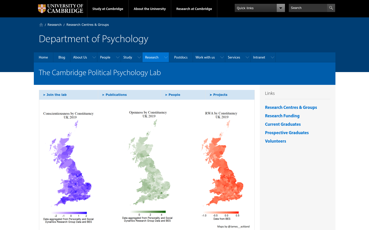
The Cambridge Political Psychology Lab
Cambridge, UKThe recently established Cambridge Political Psychology Lab attempts to apply insights from psychology to understand real world political decision making.

Global Youth Participation Index
BrusselsThe GYPI is the first global tool that tracks and compares youth political participation in over 130 countries, measuring indicators like electoral inclusion, civic engagement, youth representation in parliaments, and more.

A Roadmap for the Digital Transformation of the South African Government

Watch The Med
European Union (EU)Watch The Med is an online mapping platform to monitor the deaths and violations of migrants’ rights at the maritime borders of the EU. The WatchTheMed project was initiated as part of the 2012 Boats4People campaign in the Central Mediterranean. Today the project further involves a wide network of organisations, activists and researchers. Through the transnational cooperation with migrants’ rights organisations, activists, researchers, migrants, seafarers active in, around and beyond the Mediterranean and the use of new mapping technologies, WatchTheMed aims to document the deaths and violations that are the structural product of the militarized Southern European border regime. The online map allows to spatialise incidents across the complex legal and political geography of the Mediterranean Sea. Through the accounts of survivors and witnesses, but also the analysis of ocean currents, winds, mobile phone data and satellite imagery, it is possible to determine in which Search and Rescue zone, jurisdictions and operational areas an incident occurred – as well as showing other boats who were in the vicinity of those in distress. Spatialising such information is essential to determine responsibility for violations at sea. Apart from reconstructing past events, the participatory nature of the platform allows many different actors to to indicate ongoing situations of distress. The documentation generated by WatchTheMed seeks to support the work of organisations that defend migrants’ rights, inform migrants of their rights and security at sea, pressure authorities into respecting their obligations at sea, support the ongoing campaigns by the relatives of the dead and disappeared at sea, and support legal proceedings against those who violated the rights of migrants.

RefAid
United Kingdom of Great Britain and Northern Ireland (the)The app seeks to ensure that migrants in Europe can access trusted services and accurate information in the palm of their hand - wherever they are.

تطبیق "أزمة" ھو تطبیق فلسطیني يعرض حالة الأزمات المرورية التي تفرضھا حواجز الاحتلال

Doroob
West Bank (al-Ḍiffah al-Gharbīyah)Updated maps by local staff from your community to match map frequent changes equiped by location services.

Sakepedia and Code for SAKE
Japan (Nihon or Nippon)Crowdsourced project to collect data on sake and sake breweries from across Japan, integrates lost historical data, and utilizes digital technology to establish stronger connections between producers and consumers.

Herstory in East Asia
Republic of South Korea (Hanguk or Namhan)We want to show "herstory" in East Asia from local perspectives with a timeline and a map in our local languages, so that people from different regions of East Asia can learn more about the stories and rights women and LGBETQ+ have fought for.


Disfactory
Taipei City, TaiwanCrowdsourced reporting on Illegal Factories on Farmland in Taiwan

BKK Follow Up
Bangkok, ThailandA 12-year retrospective of problems that have bothered Bangkok residents | สำรวจปัญหากวนใจชาว กทม.

Jonmat
SeoulVerified restaurant map based on the history of congressional donations (국회의원 후원금사용내역을 기반으로 한 검증된 맛집지도)
Demokratie-Wegweiser (Democracy Guide)
Germany (Deutschland)Demokratie-Wegweiser is a digital tool that connects citizens with the right political representatives based on their location.


In this paper, we examine how AI could help reimagine local government.

Local plan policy tool
LondonLocal plan policy tool
Boston Consulting Group report

FloodGen
New York CityA flood advocacy tool that uses generative AI to visualize photorealistic images of potential flood scenarios

Tree:p is a street tree walking project encouraging people to observe and document the street trees along their daily routes using the self-guided map.

Digital Service Unit (DSU) South Africa
South Africa (South Africa, Afrika-Borwa, Suid-Afrika)To drive implementation of the Roadmap, the Presidency is establishing the Digital Service Unit (DSU) to coordinate this whole-of-government effort to modernise services.

The Life and Times of Citibike #32606
New York City806 days, 8,624 trips, 7,060 miles. Thank you for your service.
DOGE Cuts by City, State, and Congressional District
United States of America (the)Find out how the Trump administration’s DOGE cuts to grants and federal real estate are affecting your community.

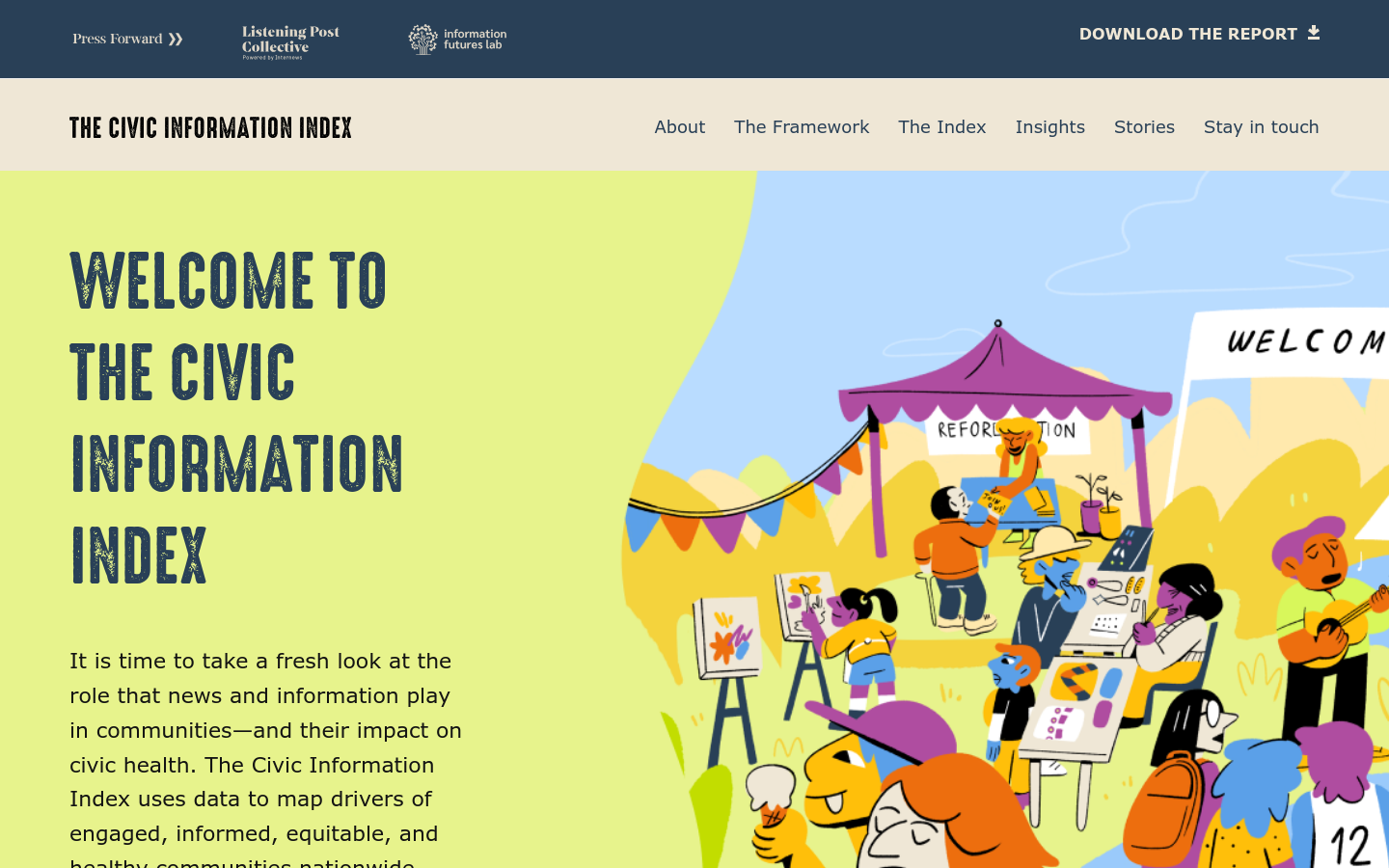
Civic Information Index
Internews Network, 15th Street Northwest, Washington, DC, USAThe Civic Information Index uses data to map drivers of engaged, informed, equitable, and healthy communities nationwide.

The Impact Project
United States of America (the)The Impact Project provides objective, transparent, and open-source data to help explain how federal policies, funding, and workforce changes affect our communities.

From advanced stakeholder mapping and relationship health tracking to sentiment and qualitative analysis, each feature works together to help your organization get more from your stakeholder relationships.

The First Branch LLM (Large Language Model) concept map below imagines the critical infrastructure needed at the enterprise level to create an accessible, accountable, and permanent information system for both the public and lawmakers.

ParticipationAI
Spain (España)ParticipationAI explores the intersection of public participation and Artificial Intelligence (AI),focusing on integrating diverse civil society perspectives into the public procurement process.

PLURALL
Paris, FrancePLURALL is a boutique consultancy firm transforming complex policy challenges into opportunities for sustainable, community-driven digital infrastructures.

Mike Tahani's data viz gallery. It includes mapping, journalism, politics, outer space, and data visualization.

Using publicly available satellite imagery and deep learning to understand economic well-being in Africa
Stanford University, Serra Mall, Stanford, CA, USAArticle in Nature by Christopher Yeh, Anthony Perez, Anne Driscoll, George Azzari, Zhongyi Tang, David Lobell, Stefano Ermon & Marshall Burke
Article in Human Service Organizations by Lauri Goldkind, Joy Ming, and Alex Fink
The Atlas project by The Sentry is a data initiative that maps, visualizes, and analyzes networks that benefit from violent conflict, repression, and kleptocracy

Updates Google Maps to show the Gulf of Mexico again.

Emerging Tech Primers
AspenOur team at Aspen Digital is defining and mapping, in plain terms, emerging technology topics to help impacted communities, social scientists, journalists, and policymakers become familiar with the issues and opportunities so that they can steer the current state and future promise of these tools.

In this paper, building on insights from the theory and practice of deliberative democracy, we provide a "Democracy Levels" framework for evaluating the degree to which decisions in a given domain are made democratically.

ARIJ has developed its AI strategy to serve as a reference and comprehensive map for small and medium-sized Arab press organizations to employ modern technologies and tools to improve journalistic production
Climate & Economic Justice Screening Tool
Washington, DCCensus tracts that are marginalized by underinvestment and overburdened by pollution are highlighted as being disadvantaged on the map. Shut down by the Trump Administration in 2025.
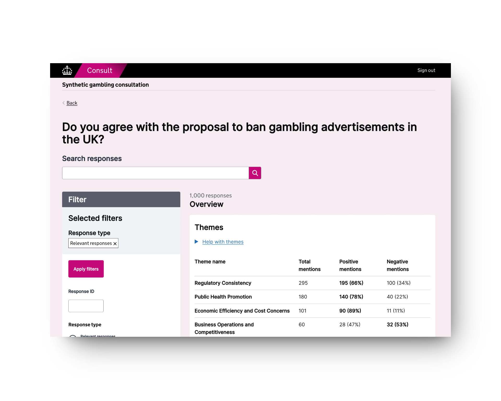
Consult (Gov.UK)
10 Downing StreetConsult is a machine learning and LLM-powered tool to automate the processing of public consultations.
This is a project that aims to broaden horizons through live-streaming webcams from around the world, allowing you to observe virtually any part of the planet.
Congestion Pricing Tracker
Brown UniversityCurious whether Congestion Pricing is having an impact on commutes in NYC? Take a look to compare traffic data before and after Congestion Pricing
Mutual Aid NYC
New York City, NY, USAA network of neighborhood groups and network builders organizing to provide aid and support to New Yorkers.
Civic Information Index
United States of America (the)The Civic Information Index uses data to map drivers of engaged, informed, equitable, and healthy communities nationwide.

Open access book by Xabier E. Barandiaran, Antonio Calleja-López, Arnau Monterde, and Carol Romero

GAMA is an easy-to-use open source modeling and simulation environment for creating spatially explicit agent-based simulations.

DC Compass
Washington, DCDC Compass, launched in March, uses generative AI to answer user questions and create maps from open data sets, ranging from the district’s population to what different trees are planted in the city.
An open source project to modernize the way in which $300 million in federal grant opportunities are shared.

A a mid-century live subway map on Kickstarter
Get email updates
Helpful Links
Reach Out
A project of

With support from
National Endowment for Democracy
Founding Organization
Civic Hall
Technology partner

 Civic Tech Field Guide