Civic Tech Field Guide
Sharing knowledge and productively growing the fieldSearch Results - app (1305)
Showing 1305 Results

Lockdown Mode is an optional, extreme protection that’s designed for the very few individuals who, because of who they are or what they do, might be personally targeted by some of the most sophisticated digital threats. Most people are never targeted by attacks of this nature.

ApplyWorks
The United Kingdom of Great Britain and Northern IrelandEasy and secure location based applications and payment services for councils.

Applied Research in Goverment Operations
525 S Hewitt St, Los Angeles, California 90013, USAA new kind of public institution, the world’s first data utility

Appgree is the only technology that can sift through the hundreds or thousands of opinions a group might have and find common ground among such a vast array of data. What’s more, it does all this in a matter of minutes.


Apple Maps COVID-19 Testing Locations
Cupertino, CAAs a healthcare provider, lab, or other business, follow these steps to submit information on COVID-19 testing locations that Apple may display to its users.

Apps for Ghent
Ghent, BelgiumWelkom op Apps For Ghent, de site voor de Gentse Open Data community. Dit is een samenwerking tussen de Stad Gent, Open Knowledge België en het Ghent Living Lab. Apps for Ghent wil via projecten, events en co-creatie het potentieel van open data in Gent maximaal benutten en de mogelijkheden ervan bij zoveel mogelijk mensen bekend maken.

AppMyCity! is a contest for the world’s best urban app

AppCivist
The CITRIS Invention LabAppCivist is a platform for democratic assembly and collective action.

Applied makes recruitment smart, fair and easy.

Apptorney
ZambiaApptorney is a platform agnostic mobile application that uses natural language processing and content indexing and categorization to provide user friendly search functionality to its users. Utilizing a dynamic search engine, users are able to navigate and search through resources that are relevant to their needs such as Legislation, Subsidiary Legislation, Fields of Law and Case Law. These are all individually indexed, cross-referenced and linked within the comprehensive master database, giving the user complete access to all relevant resources, including a lawyers/ firm repository, in one tool

Appropriate technology movement
Bonn, Germanya movement (and its manifestations) encompassing technological choice and application that is small-scale, affordable by locals, decentralized, labor-intensive, energy-efficient, environmentally sound, and locally autonomous.

AppCityLife
7801 Academy Road NE, Albuquerque, NM 87109APPCityLife is a Platform as a Service (PaaS) that empowers cities to rapidly deploy affordable mobile apps and engage citizens through CityLife Chatbot, our Artificial Intelligence chatbot built specifically for cities.


Apptivism
ScotlandHelping citizens and communities to give their view on civic issues through Messenger chatbots

Learn to make apps for Android devices by doing projects that can help people in your community.

An Open Letter To Meta in response to the company shutting down a vital tool for following discourse on Facebook
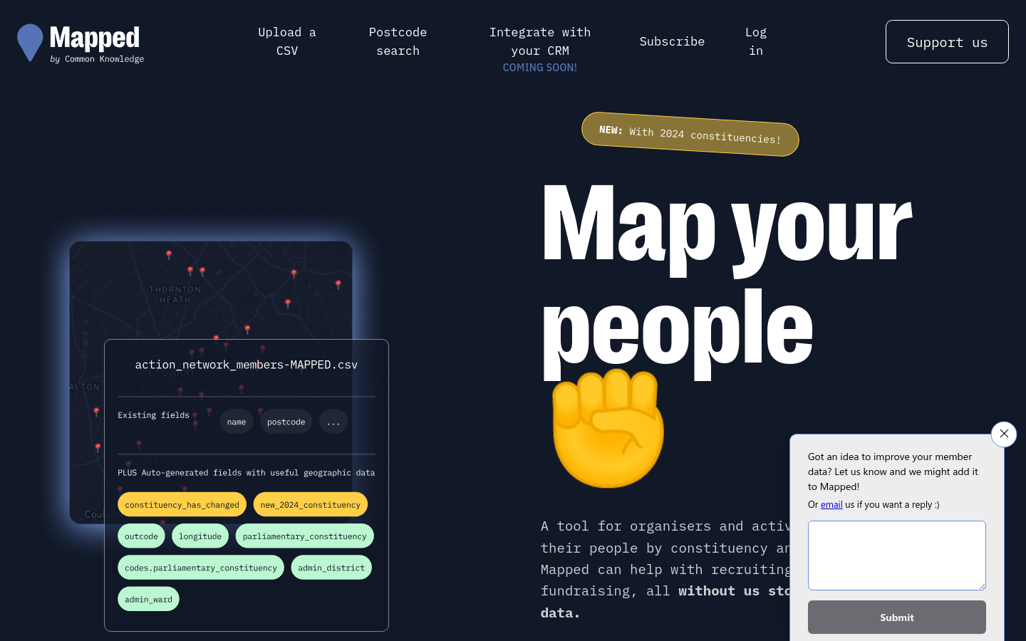
Mapped
The United Kingdom of Great Britain and Northern IrelandMapped integrates with common organising platforms like Airtable, Mailchimp and Action Network to augment membership lists with other useful data sources.

Hurricane Mapping (Sea Island Software)
Richmond, VAWe are Sea Island Software, Inc., a company specializing in hurricane threat assessment. HurricaneMapping.com is our storm tracking service for Google Earth and ESRI's ArcGIS.

Exposing protection gaps in digital transformation programmes

Whatsapp Link Extractor
LondonOur WhatsApp link extractor is a tool that makes it easy to export and download all the useful links from your WhatsApp chat history.

This is a simple app which generates a WhatsApp share link.


A Voté chatbot sur WhatsApp
Paris, FranceIl assiste les utilisateurs dans leur parcours de vote : pour vérifier leur inscription sur les listes électorales, leur rappeler les dates limites pour s’inscrire, les dates des élections 2022 et la procédure pour faire une procuration.

Krama App
Prague, CzechiaKrama App is a mobile app for responsible consumer who cares whether the business still does business in Russia or not

7 Routes to Applied Behavioural Science Experimentation and Observation
Switzerland (Schweiz, Suisse, Svizzera)A flowchart guide to help users consider which type(s) of experiments to run in policy settings

Nappal hajtva
Hungary (Magyarország)Information website by Budapest municipality in order to help the population find the possibilities of solar energy

CANVAS was founded in 2005 by Slobodan Djinovic and Srdja Popovic to advocate for the use of nonviolent resistance in the promotion of human rights and democracy. Since then, we have worked with pro-democracy activists from more than 50 countries.

Encrypted Messaging Applications and Political Messaging: How They Work and Why Understanding Them is Important for Combating Global Disinformation
The University of Texas at Austin, Austin, TX, USAThis report provides an overview of how various EMAs work, a review of popular EMAs and their notable features (LINE, Signal, Telegram, Viber, WhatsApp, and WeChat), and examples of how EMAs have been used for political manipulation

Digital Authentication and Identity Proofing in Public Benefits Applications
Georgetown University, Washington, DCCreated and published by the Digital Benefits Network, this open dataset and analysis documents identity proofing and authentication practices in online public benefits applications across the US, contributing to field-wide understanding about the digital identity landscape in public benefits, an important issue for equitable benefits access.

Trapped in a Web: The Exploitation of Personal Data in Hungary’s 2022 Elections
Hungary (Magyarország)The [Human Rights Watch] report finds that data collected by the state for administering public services, such as registering for the Covid vaccine, administering tax benefits, and mandatory membership in professional associations, was repurposed to spread Fidesz’s campaign messages.

Kyiv Digital app
KyivDigitized the city's services, including e-petition tool, and "adapted them to conditions under martial law"

Nagarikapp
NepalNepalese government mobile app for citizens

Data Mapping Cornwall
CornwallData Mapping Cornwall provides a summary of this spatial investigation of Cornwall, conducted by a large team of academics, experts and postgraduate students between September 2016 and March 2017.

Glific enables NGOs to easily scale to thousands of conversations a day with few staff.

To highlight the global knowledge base of behavioural insights work in public policy, and bring the achievements of institutions to the fore, the OECD launched the Behavioural Insights Knowledge Hub and map in 2021.

Posting towns in the USA with a population less than 1000 that are undermapped on OpenStreetMap.org

A native app that allows you to monitor more than 35 different severe weather and emergency alerts in your town, and other cities that matter to you, such as hurricanes, earthquakes and tornados.

Because OpenStreetMap is a crowd-sourcing project where everyone can freely contribute to the map, the Humanitarian OpenStreetMap Team has devised measures to support high-quality crowd-sourced OSM data.

A report by the UK Humanitarian Innovation Hub

UN Mappers is a community of mapping enthusiasts collaborating to collect, validate and disseminate geospatial open data in areas where the United Nations carries out field operations with the goal of supporting the decision-making process with more accurate location-based data.

We are identifying the organizations and leaders creating digital community-building platforms that strengthen our democracy.

Mapping NGOs Repairs
Raymond Ghosn Building, American University of Beirut, Maroun Semaan Faculty of Engineering and Architecture PO Box. 11-0236 Riad El Solh 1107 2020, Beirut LebanonBetween March and September 2021, BUL researchers identified around 80 NGOs that participated in shelter repair within the neighborhoods severely affected by the August 2020 port blast. The data and findings are presented through a recent mapping output on the Beirut Urban Observatory.

What this means is we’re putting the power into people’s hands to maintain access to WhatsApp if their connection is blocked or disrupted.

A clever campaign riffing on Spotify's Unwrapped year-in-review product, by Fight for the Future and Union of Musicians and Allied Workers. https://github.com/fightforthefuture/spotifyunwrapped.org

Congressional App Challenge
740 15th St. NW Washington D.C.We are Members of the U.S. House of Representatives hosting district-wide Congressional App Challenges for middle school and high school students, encouraging them to learn to code and inspiring them to pursue careers in computer science.
Get email updates
Helpful Links
Reach Out
A project of

With support from
National Endowment for Democracy
Founding Organization
Civic Hall
Technology partner

 Civic Tech Field Guide